

B4UW Thunder Bay to Toronto 2024 Route
The route, as presented here, starts at the Thunder Bay City Hall and, after 10 days of riding, ends at the Toronto City Hall. Both of the start and end locations can be changed as well as some portions of the route that are not on either Hwy 17 (Thunder Bay to Massey) or Hwy 6 (Espanola to South Baymouth and Tobermory south towards Owen Sound).
When can the ride occur? Window for ride September 6th-16th, 2024
Route Notes
- Day 1 Hwy 17 Thunder Bay to Nipigon
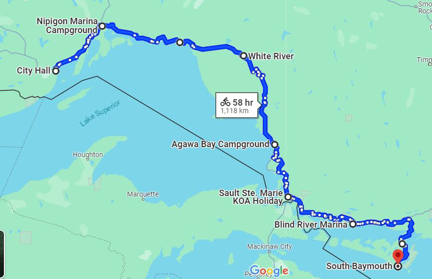
- Start: Thunder Bay City Hall
End: Nipigon Marina Campground
Route Link: https://ridewithgps.com/routes/45057407
Distance: 115km
Elevation: 689m
Notes: Thunder Bay does have bicycle lanes and bike friendly roads but not many in the direction we want to go. Hwy 17, from Thunder Bay, for about 50km, is divided and 4-lane. It is possible to avoid most of this but not all of it: there are no other options for the last 5km other than to ride it. For this reason, it would be nice to have police escort through Thunder Bay, along the route and for the 5km of 4-lane highway. - Day 2 Hwy 17 Nipigon to Neys Provincial Park
- Start: Nipigon Marina Campground
End: Neys Provincial Park
Route Link: https://ridewithgps.com/routes/45057517
Distance: 160km (to the park entrance)
Elevation: 1955m
Notes: - Day 3 Hwy 17 Neys Provincial Park to White River, (Unofficial Cyclists Campground – White River Tourist Information Centre)
- Start: Neys Provincial Park
End: White River, unofficial cyclists’ campground
Route Link: https://ridewithgps.com/routes/45057503
Distance: 115km
Elevation: 1199m
Notes: - Day 4 Hwy 17 White River to Lake Superior Provincial Park
- Start: White River, unofficial cyclists’ campground
End: Agawa Bay Campground, Lake Superior Provincial Park
Route Link: https://ridewithgps.com/routes/45057523
Distance: 177km
Elevation: 1623m
Notes: - Day 5 Hwy 17 Lake Superior Provincial Park to Sault Ste. Marie KOA
- Start: Agawa Bay Campground, Lake Superior Provincial Park
End: Sault Ste Marie, KOA
Route Link: https://ridewithgps.com/routes/45057532
Distance: 196kms
Elevation: 1195m
Notes: - Day 6 Hwy 17 Sault Ste Marie KOA. to Blind River
- Start: Sault Ste Marie, KOA
End: Blind River
Route Link: https://ridewithgps.com/routes/45057557
Distance: 151km
Elevation: 587m
Notes: Not known where to camp/stay overnight - Day 7 Hwy 17 Blind River, to Hwy 6 to Little Current
- Start: Blind River
End: Little Current
Route Link: https://ridewithgps.com/routes/45057573
Distance: 144km
Elevation: 1183m
Notes: Most of the hills are for about 20km just south of Espanola but relatively flat afterwards. Lengthening this day a bit will make tomorrow’s rush to the ferry a bit easier - Day 8 Little Current Hwy 6 South Bay Mouth 73 kms, Take Ferry to Tobermory and then cycle to Hope Bay Campground 52 kms or Owen Sound plus 30.
- Ride to ferry, take ferry, ride from ferry to Owen Sound
- Start: Little Current
End Midpoint: South Baymouth (ferry terminal)
Route Link: https://ridewithgps.com/routes/45057576
Distance: 64km
Elevation: 417m
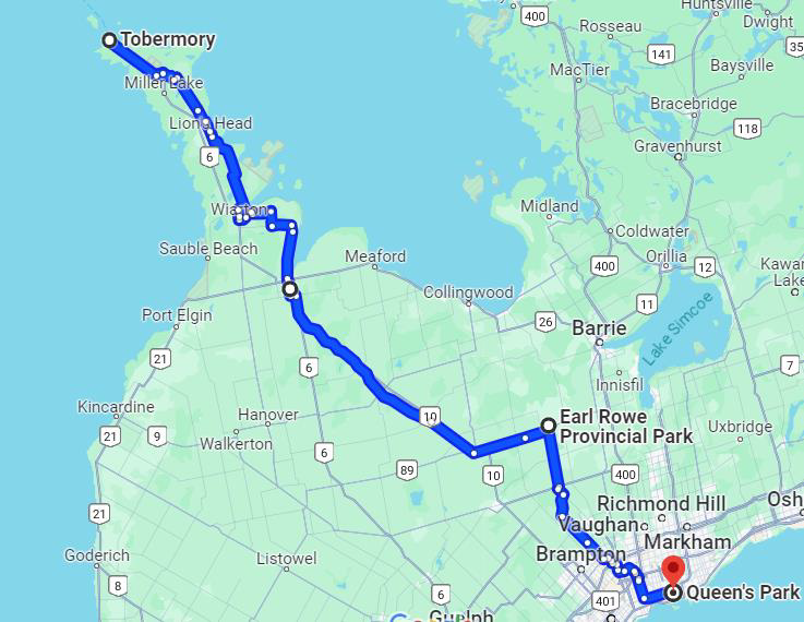
Notes: Easy ride, just one significant hill but no big deal, paved shoulder bike lane the whole way to the ferry - MS Chi Cheemaun Ferry from Manitoulin Island to Tobermory (11:00 departure; arrives at 12:45) ferries to South Tobermory
- Ride Part two: Tobermory (ferry terminal)
End: Harrison Park Campground, Owen Sound
Route Link: https://ridewithgps.com/routes/45057593
Distance: 112km
Elevation: 612m
Notes: One one route from Tobermory until closer to Owen Sound, Hwy 6 is reportedly busy. - Day 9 Owen Sound Hope Bay to Orangeville
- Start: Harrison Park Campground, Owen Sound
End: Earl Rowe Provincial Park
Route Link: https://ridewithgps.com/routes/45057609
Distance: 113km
Elevation: 909m
Notes: - Day 10 Orangeville to Toronto Queen’s Park
- Start: Earl Rowe Provincial Park
End: Toronto City Hall
Route Link: https://ridewithgps.com/routes/45057613
Distance: 82km / 107 kms
Elevation: 343m
Notes: Lots of discussion to be had regarding this portion of the route but maybe, given the “short” distance and it being the final leg, police support might be beneficial.